If your business runs vehicles that move on their own or with little supervision — survey drones, mine-site haul trucks, agricultural machinery, inspection robots, logistics fleets — your operations quietly assume that satellite positioning works. Under bridges, in pits and canyons, near jamming or simply in bad conditions, it does not. Then a vehicle has to work out where it is from what its camera sees, using a reference map captured weeks or years earlier.
The business risk is not only that it gets the position wrong. It is that it gets the position wrong confidently: the system reports a plausible fix, the vehicle acts on it, and you find out from the damage, the lost asset or the incident report. When you are buying navigation capability, every vendor will show you the runs that worked. Very few can show you, in a form you can check, where their method fails and whether it knows that it is failing.
What a digital twin means here
A digital twin is a model of a real system that can be questioned and run. In navigation the useful form is a digital shadow — generation 2 in our framework. Observations flow one way into the model, and the model estimates where the vehicle is right now, with error bounds. It does not steer the vehicle or run "what if we drove differently" scenarios; it answers one hard question honestly: given only what the camera sees, where are we, and how sure should we be?
That is narrower than a full twin, and deliberately so. For buyers of autonomy, a trustworthy estimate with a well-behaved "I don't know" is worth more than an ambitious system that cannot be audited. When you later need route planning, fleet coordination or mission rehearsal, the shadow becomes the state estimate those higher layers build on.
What we built
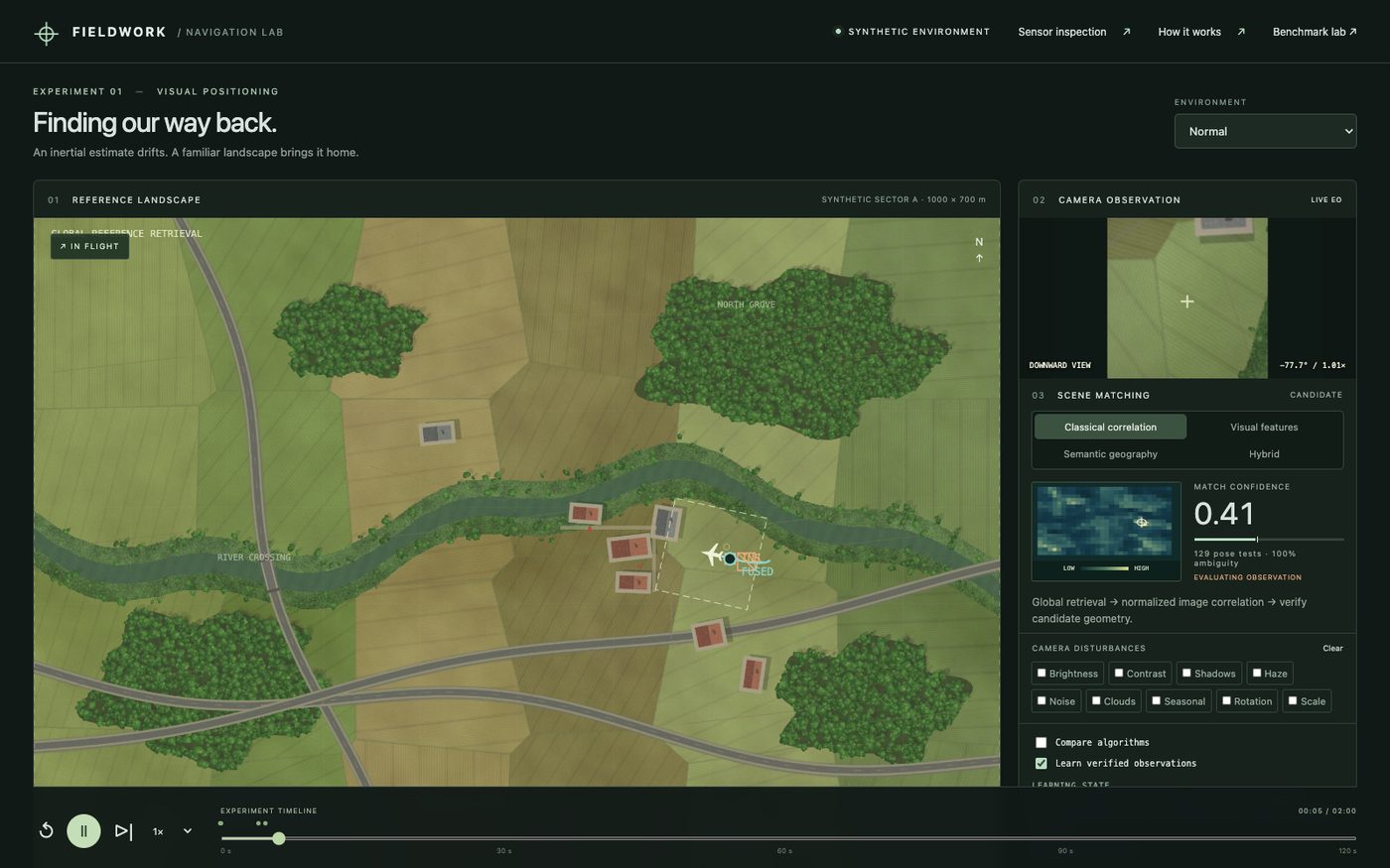
Fieldwork — Visual Localization is a browser research sandbox for observation-based localisation in a fully synthetic world. The reference map and the live camera images are independent renders of the same underlying terrain — roads, parcels, trees, buildings — so the method cannot cheat by matching an image against itself. There is no satellite-imagery background and no pretrained model. Ground truth is held only by the evaluator, never by the algorithms.
Four approaches are compared on identical pixels, the same nominal camera pose and the same inertial (INS) prior:
- classical image correlation;
- local visual features;
- semantic geography (roads, junctions and other structure extracted from pixels);
- a hybrid that combines them and inspects the evidence behind each candidate before accepting it.
The benchmark covers 9 scene types (normal, cloud, lighting, seasonal change, rotation, scale, large INS drift, low texture and deliberately repetitive terrain), 3 severity levels and 20 observations each: 27 cases and 2,300 recorded rows, with failures kept in the published JSON and CSV. In normal conditions the hybrid method produced an accepted, correct fix (within 10 m) on 19 of 20 observations at the two lower severities and 16 of 20 at the highest. On low-texture scenes it rejected every observation rather than guess, and on the repetitive scene it accepted 1 of 20 at the lowest severity and none after that. A guarded observation memory admitted six new records during a learning run; all six were audited correct, with no wrong admissions.
Questions it helps a buyer answer
- Under which conditions — cloud, season, lighting, rotation, drift — does a localisation method hold up, and where does it fall apart?
- When the method is wrong, does it know? How often does it accept a plausible but wrong position?
- Which ingredient actually carries the result? (The sandbox can switch off appearance, features, semantic geography, the prior or memory, and rerun.)
- Is "learning on the job" improving accuracy, or quietly adding bad data to the map?
- What would we need to see before letting a fix steer a real vehicle?
What changes
Before: navigation performance is a demo video and a headline accuracy number. Failures show up in the field. Comparing vendors means comparing slide decks.
After: you have a repeatable test bench with seeded runs, the truth kept away from the algorithm, and every failure in the record. Decisions about which method to deploy, under which conditions, and with what fallback, are made on evidence. "Refuse the fix" becomes a measured behaviour rather than a hope.
Getting there
To move from the sandbox to your operation, we would typically need:
- reference imagery or maps of your operating area, and representative live imagery from your cameras;
- camera parameters and mounting, and your inertial navigation characteristics;
- the conditions that matter to you (season, weather, altitude, terrain type);
- your acceptance rule: what error is tolerable, and what a vehicle should do when no fix is accepted.
The path is the same as for any twin: discovery to agree the operating envelope and acceptance rules; a prototype benchmark on your own imagery; then integration with the vehicle's navigation stack as a connected estimator running in shadow mode before it is trusted.
Questions worth asking any navigation vendor: Who holds the ground truth during evaluation? Are failures and false accepts reported, or only successes? Is the confidence a calibrated probability or a heuristic? What happens when the system is unsure?
Honest limits
Fieldwork runs in a synthetic world; it is not a flight-qualified or safety-certified system and has not been evaluated on real vehicle imagery. Its confidence values are heuristic scores, not calibrated probabilities. Results come from one seeded experiment and describe this sandbox, not your terrain. The INS model is illustrative. The value it offers today is a method and a test discipline — not a product you can fit to a vehicle tomorrow.
See it
- Live sandbox: navigation.octopustwin.com
- Case study: Fieldwork — Visual Localization
- Research report: navigation research
- Talk to us about your operating area: contact